Madeira rises sharply from the Atlantic, with houses climbing the hills above Funchal and mountain ridges standing behind them. Follow a road inland and the sea can disappear behind a valley wall. Continue higher and the surroundings change again: cultivated terraces give way to forest, cloud and exposed rock. The island is small enough to study on a single map, but its height gives it far more variety than its outline suggests.
Yet Madeira is also the name commonly used for a wider Portuguese island region. Beyond the main island lies Porto Santo, known for its long sandy beach, along with the protected Desertas and Selvagens island groups. Together, they tell a broader story about Atlantic settlement, maritime trade, agriculture and the survival of plants and animals found in very few other places.
To understand the Madeira archipelago, it helps to look beyond any single photograph. The mountains matter, but so do the irrigation channels crossing their slopes, the working streets of Funchal and the smaller islands whose importance comes from their wildlife rather than their visitor facilities.
Where Is Madeira, and Which Islands Belong to the Archipelago?
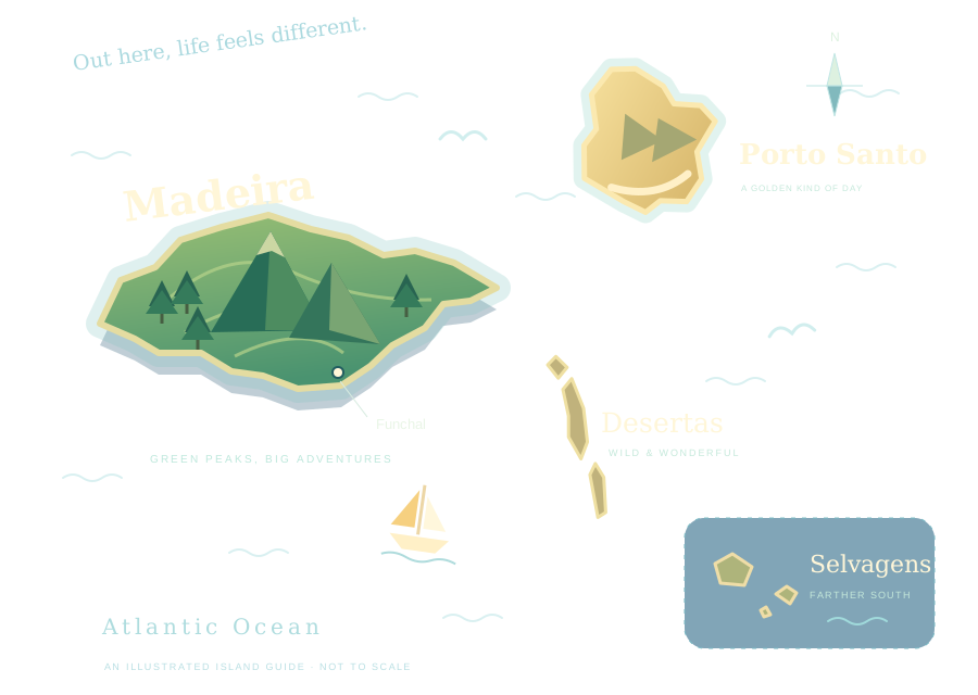
The Madeira archipelago lies in the North Atlantic, southwest of mainland Portugal and north of the Canary Islands. It forms the Autonomous Region of Madeira, part of Portugal. Portuguese is the official language, and the euro is the currency. Its Atlantic position helps explain both its maritime history and the contrast between its European institutions and subtropical coastal vegetation.
The regional tourism board identifies Madeira, Porto Santo, the Desertas and the Selvagens as the archipelago’s island groups. Madeira and Porto Santo have settled civilian populations. The Desertas and Selvagens are protected natural areas, where conservation and scientific work take priority over ordinary development.
Madeira island contains Funchal, the regional capital, and most of the region’s population and services. Porto Santo has a different scale and physical character. The smaller protected islands should not be thought of as additional resort stops. An archipelago can share an administration and a history without every island offering the same experience.

An Island Shaped by Height
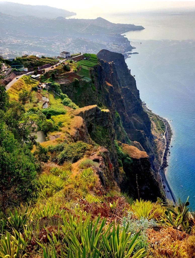
Madeira’s volcanic origins are visible in its dark coastal rock, steep cliffs and mountain formations. Erosion has cut valleys through the island, leaving relatively little broad, level ground. That physical shape influences almost everything people do here, from building roads to growing crops.
The highest point is Pico Ruivo, at 1,862 metres. From the central mountains, ridges fall away into valleys and toward the coast. On clear days, these heights reveal how closely sea, settlement and upland terrain sit together. When cloud moves in, the same view can shrink to the next bend in the path.
Distance therefore needs to be considered alongside elevation. Two places that appear close on a map may lie on opposite sides of a substantial ridge. Modern tunnels make many journeys easier, but they do not flatten the island. Walking a kilometre uphill and walking a kilometre along the waterfront remain rather different arrangements with your legs.
Portuguese Settlement and Atlantic Trade
The conventional account of Portuguese arrival places the navigators on Porto Santo in 1418 and Madeira in 1419. The name Madeira means wood, referring to the forest that covered the island. Organized settlement followed during the fifteenth century, bringing changes to land use, water management and the coast.
According to the regional tourism board’s history of Madeira, settlement developed under the Portuguese crown and the islands became connected to expanding Atlantic commerce. Agriculture required clearing and cultivating difficult ground. Sugar became an important export, followed by the growing international reputation of Madeira wine.
This history helps explain why an island far from continental Europe developed connections with foreign merchants and overseas markets. Funchal was a port through which goods, people and ideas moved. The region’s identity grew from those exchanges as well as from its geographical isolation.
For a fuller account, agricultural and trading history should be read alongside the lives of the people who performed the work. Terraces and water channels represent generations of labor. Their attractiveness today should not obscure the effort required to construct and maintain them.
Funchal: The Archipelago’s Urban Centre
Funchal occupies a south-facing bay, with its streets extending uphill from the waterfront. It is the region’s administrative and commercial centre as well as a visitor destination. The harbour, shops, restaurants and residential neighbourhoods belong to the same functioning city, even where the holiday scene is most visible.
The older streets reward attention at walking pace. Cobbled surfaces, façades, doorways and small squares provide a different sense of scale from the broad waterfront. The tourism board’s account of downtown Funchal captures this compact urban character. Much of the interest lies in how ordinary businesses occupy older buildings rather than in any one landmark.
Funchal Cathedral connects the present city with its earlier prosperity. Its Gothic and Manueline features, together with its celebrated wooden ceiling, make it a useful place to examine the craftsmanship and religious patronage of the period.
The city also changes as you climb. Looking back toward the harbour makes the relationship between buildings and terrain clearer: development follows slopes rather than spreading across a plain. Funchal introduces a pattern repeated throughout Madeira, where even an everyday walk can become a lesson in topography.
The North Coast, South Coast and Mountain Interior
The different parts of Madeira have recognizably different characters. The official overview of Madeira island distinguishes the greener northern slopes, the settlements of the south and the high central mountains. These differences are useful when trying to understand the island as a place rather than a collection of attractions.
On the north coast, steep ground meets the Atlantic with little room to spare. Valleys carry greenery down toward settlements and the sea. Along the south, towns and cultivated slopes share space with coastal bathing areas. Inland, roads and paths enter a more enclosed geography before reaching open heights.
These contrasts make short journeys feel substantial. Moving from a town centre to a forested valley is not simply changing the view; it can mean different light, temperature and exposure to wind. The island’s variety is best appreciated by allowing each setting some time, rather than treating every stop as another photograph to collect.
The Laurisilva Forest
Madeira’s Laurisilva is one of its most important natural features. This evergreen laurel forest survives from a forest type that was once much more widespread. UNESCO inscribed the Laurisilva of Madeira as a World Heritage Site in 1999, recognizing its ecological value and exceptional state of preservation.
The protected property covers about 15,000 hectares. It supports endemic plants and animals, including the Madeiran laurel pigeon, and plays an important role in the island’s water balance. Forest here is more than a green background: it is habitat, shelter and part of the system that captures and regulates moisture.
Its character is often easiest to appreciate through smaller details. Ferns fill shaded ground, mosses cover trunks and stones, and old trees occupy steep valleys. The experience differs from walking through a planted park. Irregular growth, damp surfaces and the sound of water give the forest its own pace.
Its survival also gives perspective to the cultivated parts of Madeira. The forest and the terraces tell connected stories about what was preserved, what was altered and how the island’s water continues to link the two.
Levadas: Waterways Before Walking Routes
Levadas are channels built to carry water across Madeira’s difficult terrain. They follow contours, cross steep slopes and help move water to places where it is needed. Their narrow accompanying paths have become closely associated with walking, but the channels themselves are working infrastructure with an agricultural purpose.
That purpose changes how a levada walk can be understood. A route maintaining a gentle gradient along a steep hillside reflects the need to control flowing water. Tunnels and cuttings are evidence of engineering decisions, not features installed to make a scenic outing more entertaining.
The wider network includes both levada routes and mountain footpaths, often called veredas. Their demands vary. A route beside water is not automatically easy, particularly where the path is narrow or exposed. The official walking route listings provide current information on access, conditions and applicable arrangements.
For the island’s story, the most interesting point is the connection between engineering and cultivation. Water flowing beside a walker may also support land farther down the slope. The path gives access to a system that helped make settlement possible.
The Atlantic Shore and Porto Moniz
Madeira’s coast frequently brings rock and sea together with very little sand between them. This makes its bathing places different from those of an island dominated by broad beaches. The appeal often comes from swimming close to cliffs or volcanic formations, with the open Atlantic visible beyond.
The natural pools at Porto Moniz are a well-known example. Volcanic rock forms basins replenished by seawater, while developed facilities make parts of the site accessible for bathing. Their appearance comes from the meeting of old lava formations and a constantly moving ocean.
The distinction between a managed bathing area and the surrounding coast matters. An attractive photograph cannot describe the day’s sea conditions. Local notices and operating conditions are more useful than assuming that every pool or shoreline is suitable for swimming whenever the sun appears.
Even without entering the water, these places explain something about Madeira. The coast is not just the island’s edge. It is where its geology becomes visible and where the ocean continues to reshape the rock.
Porto Santo: A Different Side of the Region
Porto Santo provides the clearest contrast with Madeira island. Its best-known feature is a golden sandy beach extending for about nine kilometres. The broad shoreline and more open setting give it a different visual character from Madeira’s steep green valleys and rocky bathing places.
That difference deserves more than a passing mention. A person arriving with an image of Madeira’s forested mountains may be surprised by Porto Santo’s comparatively dry appearance. Sharing the same regional identity has not made the islands physically alike. Their contrast is part of the reason to consider the archipelago as a whole.
There is also more to Porto Santo than its beach. The island’s official visitor guide includes viewpoints, walking areas and cultural sites around Vila Baleira and beyond. Inland rises provide a wider view of the coast, while the town gives context to an island that is sometimes reduced to a strip of sand in travel photographs.
Madeira and Porto Santo need not compete for the same role. One offers a dense sequence of mountain, forest and urban settings; the other allows more attention to a long shoreline and a smaller town. Together they broaden the region’s appeal without needing to resemble each other.

The Desertas and Selvagens
The Desertas and Selvagens make the archipelago more than a pairing of populated holiday islands. Their value lies largely in protected habitats, seabird colonies and conservation. They have no equivalent to Funchal’s urban centre or Porto Santo’s beach town.
The Desertas are associated with the conservation of Mediterranean monk seals. The Selvagens are important for breeding seabirds. Portugal’s official tourism account of rare species in the Madeira region describes the different habitats and animals supported by these islands. Their isolation can offer wildlife a refuge, but it also makes disturbance and introduced species serious concerns.
These protected areas should be approached according to their conservation rules and authorized access arrangements. They are not places to treat as unrestricted extensions of a beach holiday. Research, wardening and habitat protection are central to their role within the region.
Their inclusion also changes the way the archipelago appears on a map. Small islands can carry ecological importance out of proportion to their size. A place need not contain a town or receive large numbers of visitors to be central to Madeira’s identity.
Climate: Mild Coasts, Cooler Heights
Madeira is often described through its mild coastal climate, but one temperature cannot describe the whole island. Altitude, exposure and the orientation of slopes create substantial local differences. Conditions near the waterfront may tell you little about what is happening in the central mountains.
The regional conservation institute’s publication on Madeira’s eastern mountain massif explains how the island’s relief and prevailing winds contribute to these microclimates. Higher areas are colder, while sheltered and exposed slopes respond differently to the same weather pattern.
This variation helps account for the range of vegetation visible over relatively short distances. It also means that a day should not be planned entirely around the weather outside a hotel window. Conditions are best checked for the actual area being visited, particularly when that area is far above sea level.
For an account of the islands themselves, the weather is part of the explanation rather than a selling point. Clouds, wind and rainfall help create the forest, influence agriculture and give Madeira its changing appearance. An island that is always pictured in sunshine is only partly described.
Food That Reflects the Islands
Madeiran food draws on both the sea and cultivated land. Fish and shellfish sit alongside beef, bread, vegetables and fruit. The result is a regional cuisine that makes sense in a place where fishing communities and agricultural slopes are often close neighbours.
Among the best-known dishes is espetada, beef cooked on a skewer, traditionally associated with laurel wood. Bolo do caco is a flat, round bread often served warm with garlic butter. Milho frito, fried pieces of cooked maize preparation, is another familiar accompaniment. The official guide to traditional Madeiran food introduces these regional staples.
Poncha, made with sugarcane spirit and ingredients such as citrus and honey, belongs to the same food culture. Bolo de mel, a rich cake associated with sugarcane syrup, points back to the island’s agricultural history. Recipes and serving habits vary, which is part of their interest.
The useful approach is to notice the ingredients and preparation rather than hunt for one supposedly definitive meal. Regional cooking survives through repetition in homes and businesses, with variations that a short list of famous dishes cannot fully capture.
Madeira Wine and the Island’s Overseas Connections
Madeira wine carries the island’s name far beyond Portugal. It is a fortified wine, made in a range of styles rather than a single level of sweetness. The names Sercial, Verdelho, Boal and Malvasia are closely associated with its traditions, as described in Portugal’s introduction to Madeira wine.
Its history belongs to the history of shipping and trade. Wine could connect a small agricultural region to distant consumers, merchants and ports. A bottle is therefore also a record of commercial relationships: the land where grapes grew, the people who made the wine and the overseas buyers who helped establish its reputation.
For someone unfamiliar with Madeira, the variety matters. Treating every bottle as a sweet after-dinner drink misses the differences between styles. Comparing a drier example with a richer one can be more informative than simply buying a bottle because the label carries the island’s name.
Wine also links the visitor’s experience back to the working countryside. Vineyards are agriculture before they are scenery. Their continued use depends on skills, labor and an economic reason to keep producing.
Embroidery, Craft and Public Celebrations
Madeira embroidery is another regional product with an international history. Handwork, detailed stitching and designs inspired by natural forms distinguish the tradition. Its export trade expanded during the nineteenth century, helping turn a domestic skill into a recognized commercial craft.
Looking closely at an embroidered piece changes the conversation from souvenirs to time and workmanship. The material, pattern and density of stitching all affect the work involved. The regional institute’s certification helps distinguish authentic Madeira embroidery, giving buyers something more useful than a seller’s general claim that an item is local.
Public celebrations provide another expression of regional culture. Madeira’s official events calendar includes festivities connected with flowers, wine, music and local communities. Their appeal lies partly in seeing streets and public spaces used collectively, with preparations and participation extending beyond the main performance.
Dates and programmes should be checked for the year of travel. More broadly, these traditions show that Madeira’s identity is maintained through things people do: making, cooking, growing, playing music and gathering together. It is not contained only in historic buildings or protected countryside.
Allowing Time for the Place
A useful way to approach Madeira is to choose a few areas and spend time within them. Combining a coastal settlement with its surrounding countryside can reveal more than crossing the island repeatedly to reach unrelated viewpoints. The relationship between a town, its roads and its cultivated slopes becomes clearer when the journey itself receives some attention.
The same principle applies to Porto Santo. Time away from the beach adds context, while time on the beach need not be filled with activities. In both islands, leave enough flexibility for weather and ordinary pauses. A bakery, a small square or a conversation about how something is made can become as memorable as a famous viewpoint.
Seeing the Archipelago as a Whole
Madeira makes most sense when its different parts are connected. The forest helps explain the water supply. The water channels help explain cultivation. Agriculture leads to food and wine, while the harbour explains how local products reached distant markets. The mountains that attract walkers are also the terrain that generations of residents had to work around.
Porto Santo adds a different coastline and scale of settlement. The Desertas and Selvagens extend the story into wildlife conservation and the importance of leaving some places largely undeveloped. Funchal brings the region’s administrative, commercial and cultural activity into one urban centre.
A good introduction to Madeira leaves room for all of these. A mountain view, an old street, a water channel and a meal each reveal something different. Taken together, they describe an Atlantic archipelago shaped by its terrain, connected through the sea and sustained by the people who continue to live and work there.